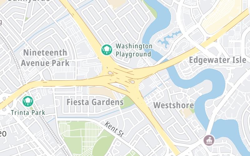
This is Exit 13A/B of the San Mateo Hayward Bridge.
This junction is located in San Mateo.
This location is in the San Francisco Bay Area area.
This location's approximate GPS Coordinates are 37.55310 x -122.29541.
Which directions can I travel from here?
From this junction, traffic can enter traveling both westbound and eastbound. Traffic can also exit traveling both westbound and eastbound.
The next exit is Edgewater Blvd/Mariners Island Blvd, approximately 0.7 miles away ►
Which direction are tolls charged here?
Tolls are not charged or collected at this junction.
Above: Map image © TomTom Intl BVThe interactive map and lists on this page include key traveler services within two miles of this destination point.
You will find common services, including gas stations, truck stops, EV charging facilities, fast-food or family restaurants, and hotels. These are displayed on the interactive map as markers, which you can select for more information.
Current driving conditions and weather, along with a more complete list of key services, may be found below the map.
A summary of the closest services around the San Mateo Hayward Bridge and US 101 is shown below. More complete detail follows the map.
Pan and zoom the map as you desire, and select markers for information and other options, including online ordering, where available.
Cloudy
57°F / 14°C
Feels Like:
53°F / 11.4°C
Visibility
8 Mi / 12.9 Km
3-Hour Precip:
0.06 In / 0.2 Cm
South Southeast
Winds (SSE)
7.2 MPH / 11.6 KPH
Gusts:
16.5 MPH / 26.5 KPH
▸ Get the full forecast for This Location | The San Francisco Bay Area area
Closest Gas Stations
EXXON
404 19th Avenue • 0.53 miles
Store/Fuel Brand: Exxon
BP STATION
South Delaware Street • 0.55 miles
Store/Fuel Brand: BP
ARCO
1950 South Delaware Street • 0.58 miles
Store/Fuel Brand:
FOSTER CITY VALERO
1622 South Grant Street • 0.66 miles
Store/Fuel Brand: Valero
Closest EV Chargers
CHARGEPOINT
1410 Fashion Island Boulevard • 0.40 miles
CONNECTOR: IEC62196Type1
POWER: 6 KW @ 240 V
CURRENT: 28 Amp AC1
CHARGEPOINT
1410 Fashion Island Boulevard • 0.41 miles
CONNECTOR: IEC62196Type1
POWER: 6 KW @ 240 V
CURRENT: 28 Amp AC1
CHARGEPOINT
1410 Fashion Island Boulevard • 0.41 miles
CONNECTOR: IEC62196Type1
POWER: 6 KW @ 240 V
CURRENT: 27 Amp AC1
1410 FASHION ISLAND BOULEVARD GARAGE
1410 Fashion Island Boulevard • 0.45 miles
CONNECTOR: IEC62196Type1
POWER: 6 KW @ 240 V
CURRENT: 27 Amp AC1
Closest Fast Food
Fast food refers ONLY to quick-service and take-out diners. All restaurant types are shown on the map below.
QUIZNOS
1001 Park Place • 0.61 miles
MENDOCINO FARMS
1060 Park Place • 0.62 miles
CHIPOTLE
1050 Park Place • 0.62 miles
THE HABIT BURGER GRILL
1100 Park Pl Bldg 2 • 0.63 miles
CALIFORNIA FISH GRILL
2214 Bridgepointe Parkway • 0.77 miles
CHICK-FIL-A
2210 Bridgepointe Parkway • 0.78 miles
TACO BELL
1975 South El Camino Real • 0.85 miles
BURGER KING
2817 South El Camino Real • 0.86 miles
Hotels closest to US 101.
Select/Tap Vendors For Info
Open the columns below to show address, phone numbers and available URLs for gas stations, EV charging stations and fast-food dining within about two miles of US 101 and the San Mateo Hayward Bridge.
Journey to key destinations around and adjacent to California!
Communities in this metro area include Los Angeles, Long Beach, Irvine, San Juan Capistrano, and Santa Ana.
Individual toll maps for this region are listed below.
Communities in this metro area include San Francisco, San Jose, Sausalito, and Menlo Park.
Individual toll maps for this region are listed below.
Communities in this metro area include San Diego, Chula Vista, and Tijuana, Mexico.
Individual toll maps for this region are listed below.