Map & services within two (2) miles
Interactive map shows available cameras, plus nearby fuel, food and lodging


See below for more about this area
Interactive map shows available cameras, plus nearby fuel, food and lodging
See below for more about this area
This junction is located in Irvine. NOTE: NB off / SB on only.
This location is in the Greater Los Angeles area.
This location's approximate GPS Coordinates are 33.71472 x -117.79865.
Which directions can I travel from here?
From this junction, traffic can only enter going southbound. Traffic can only exit going northbound.
On to Irvine Boulevard, about 1.2 miles away ►
◄ Back to Walnut Ave, about 0.5 miles away.
Which direction are tolls charged here?
Tolls are not charged or collected at this junction.
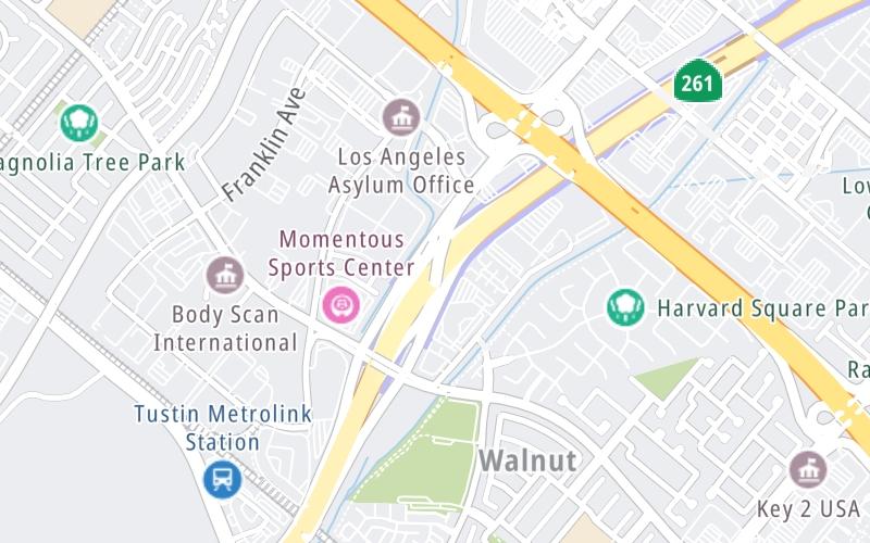
Above: Map image © TomTom Intl BVThe interactive map and lists on this page include key traveler services within two miles of this destination point.
You will find common services, including gas stations, truck stops, EV charging facilities, fast-food or family restaurants, and hotels. These are displayed on the interactive map as markers, which you can select for more information.
Current driving conditions and weather, along with a more complete list of key services, may be found below the map.

Sunny
56°F / 13.6°C
Feels Like:
61°F / 15.9°C
Visibility
11 Mi / 17.7 Km
3-Hour Precip:
0 In / 0.0 Cm
West
Winds (W)
1.8 MPH / 2.9 KPH
Gusts:
6.1 MPH / 9.8 KPH
▸ Get the full forecast for This Location | The Greater Los Angeles area
Conditions and forecasts provided in partnership with AccuWeather.

Weather provided in partnership with AccuWeather.

CA-261 @ IRVINE BLVD
Camera Direction: NORTH. Source: Caltrans - Los Angeles 92602
Cameras Closest To I-5 via Jamboree Rd
1.31 Mi
1.77 Mi
2.41 Mi
2.54 Mi
3.07 Mi
There are no currently-available photos for this location.
The map above shows all services within about a two (2) mile radius.

Destination Travel

Closest Gas Stations
IRVINE AUTO CARE
3097 Edinger Avenue • 0.73 miles
Store/Fuel Brand:
MOBIL
14493 Culver Drive • 0.91 miles
Store/Fuel Brand: Mobil
CHEVRON
2740 Bryan Avenue • 0.93 miles
Store/Fuel Brand: Chevron
CHEVRON
14446 Culver Drive • 0.96 miles
Store/Fuel Brand: Chevron
Closest EV Chargers
CHARGEPOINT
3002 Dow Avenue • 0.57 miles
CONNECTOR: IEC62196Type1
POWER: 6 KW @ 240 V
CURRENT: 27 Amp AC1
CHARGEPOINT
3200 El Camino Real • 0.57 miles
CONNECTOR: IEC62196Type1
POWER: 6 KW @ 240 V
CURRENT: 27 Amp AC1
CHARGEPOINT
200 Commerce • 0.65 miles
CONNECTOR: IEC62196Type1
POWER: 6 KW @ 240 V
CURRENT: 27 Amp AC1
TUSTIN TOYOTA GIANT USED CAR CENTER
44 Auto Center Drive • 0.66 miles
CONNECTOR: IEC62196Type1
POWER: 7 KW @ 240 V
CURRENT: 30 Amp AC1

Closest Fast Food
Fast food refers ONLY to quick-service and take-out diners. All restaurant types are shown on the map above.
KRISPY KREME
13672 Jamboree Road • 0.51 miles
HOPDODDY BURGER BAR
3030 El Camino Real • 0.60 miles
IN-N-OUT BURGER
3020 El Camino Real • 0.63 miles
TACO BELL
3010 El Camino Real • 0.64 miles
EL POLLO LOCO
3002 El Camino Real • 0.66 miles
WHICH WICH?
2941 El Camino Real • 0.74 miles
DAIRY QUEEN
El Camino Real • 0.74 miles
RUBIO'S
2955 El Camino Real • 0.75 miles
Journey to key destinations around and adjacent to California!
Communities in this metro area include Los Angeles, Long Beach, Irvine, San Juan Capistrano, and Santa Ana.
Individual toll maps for this region are listed below.
Communities in this metro area include San Francisco, San Jose, Sausalito, and Menlo Park.
Individual toll maps for this region are listed below.
Communities in this metro area include San Diego, Chula Vista, and Tijuana, Mexico.
Individual toll maps for this region are listed below.
 CA 73 ▹
 CA 133 ▹
 CA 241 ▹
 CA 261 ▹
 Antioch Bridge ▹
 Benicia Martinez Bridge ▹
 Carquinez Bridge ▹
 Dumbarton Bridge ▹
 Golden Gate Bridge ▹
 Richmond San Rafael Bridge ▹
 San Mateo Hayward Bridge ▹
 South Bay Expressway ▹


