South Bay Expressway At CA 54 / CA 125

Advertising
Advertising

Map & services within two (2) miles

Interactive map shows available cameras, plus nearby fuel, food and lodging

See below for more about this area

Advertising
Advertising

About This Location

CA 54 / CA 125

At A Glance

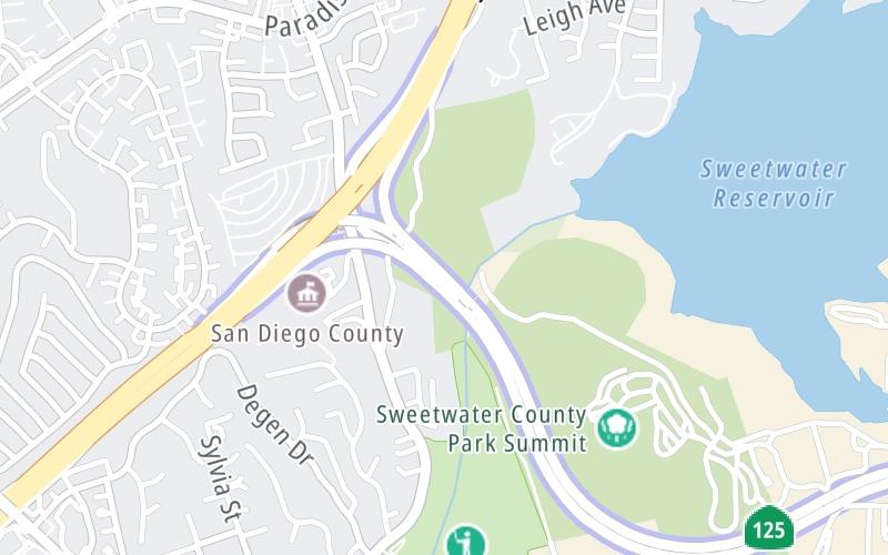
This is Exit 11/11A of the South Bay Expressway.

This junction is located in La Presa. San Diego is nearby.

This location is in the San Diego area.

Interactive Map Above

This location's approximate GPS Coordinates are 32.68896 x -117.01317.

Which directions can I travel from here?

From this junction, traffic can only enter going southbound. Traffic can only exit going northbound.

◄ Back to San Miguel Ranch Road, about 2.6 miles away.

Which direction are tolls charged here?

Tolls are not charged or collected at this junction.

View Map Travel Conditions

Above: Map image © TomTom Intl BV

Using The POI Map

The interactive map and lists on this page include key traveler services within two miles of this destination point.

You will find common services, including gas stations, truck stops, EV charging facilities, fast-food or family restaurants, and hotels. These are displayed on the interactive map as markers, which you can select for more information.

Current driving conditions and weather, along with a more complete list of key services, may be found below the map.

View Map Weather

Static map of South Bay Expressway at CA 54 / CA 125
Static map. Interactive map is above.
Advertising
Advertising

Travel Conditions At CA 54 / CA 125

Current Weather And Visibility

  • 08 7 03
  • Cloudy

    55°F / 13°C

    Feels Like:

    56°F / 13.3°C

  • Visibility

    9 Mi / 14.5 Km

    3-Hour Precip:

    0 In / 0.0 Cm

  • South Southeast
    Winds (SSE)

    1.6 MPH / 2.6 KPH

    Gusts:

    3.3 MPH / 5.4 KPH

▸ Get the full forecast for This Location | The San Diego area

Available Cameras

No camera feed …

There is no currently-available traffic camera feed for this location.

Advertising
Advertising

Travel Pictures

No photos …

There are no currently-available photos for this location.

Advertising
Advertising

Closest Food, Gas, EV And Other Services Near CA 54 / CA 125

The map above shows all services within about a two (2) mile radius.

Hotels and destinations header

Hotels & Airports

Destination Travel

Fuel, EV and convenience store header

Gas & EV Charging

Closest Gas Stations

7-Eleven

7-ELEVEN

103 Worthington Street • 0.68 miles

Store/Fuel Brand: 7-Eleven

ARCO

495 South Meadowbrook Drive • 0.96 miles

Store/Fuel Brand:

76

ROCKET

481 Sweetwater Road • 1.22 miles

Store/Fuel Brand: 76

7-Eleven

7-ELEVEN

5188 Bonita Road • 1.24 miles

Store/Fuel Brand: 7-Eleven

View Map

Closest EV Chargers

View Map

No EV charging stations nearby.

Coffee, snacks and dining header

Fast Food & Beverage

Closest Fast Food

Fast food refers ONLY to quick-service and take-out diners. All restaurant types are shown on the map above.

Taco Bell

TACO BELL

8330 Paradise Valley Road • 0.70 miles

KFC

KFC

8330 Paradise Valley Road • 0.70 miles

McDonald's

MCDONALD'S

8730 Jamacha Boulevard • 1.27 miles

LITTLE CAESARS

539 Sweetwater Road • 1.30 miles

KFC

KFC

5080 Bonita Road • 1.40 miles

Chick-fil-A

CHICK-FIL-A

931 Sweetwater Road • 1.64 miles

JERSEY MIKE'S SUBS

937 Sweetwater Road • 1.65 miles

YOSHINOYA

1025 Sweetwater Road • 1.71 miles

View Map

Discover California Attractions

Advertising
Advertising

EXPLORE CALIFORNIA

Journey to key destinations around and adjacent to California!

Map Of This Region ▹

Communities in this metro area include Los Angeles, Long Beach, Irvine, San Juan Capistrano, and Santa Ana.

Individual toll maps for this region are listed below.

Map Of This Region ▹

Communities in this metro area include San Diego, Chula Vista, and Tijuana, Mexico.

Individual toll maps for this region are listed below.

Advertising
Advertising
Turnpikes.com is proud to partner with the following: