Map & services within two (2) miles
Interactive map shows available cameras, plus nearby fuel, food and lodging


See below for more about this area
Interactive map shows available cameras, plus nearby fuel, food and lodging
See below for more about this area
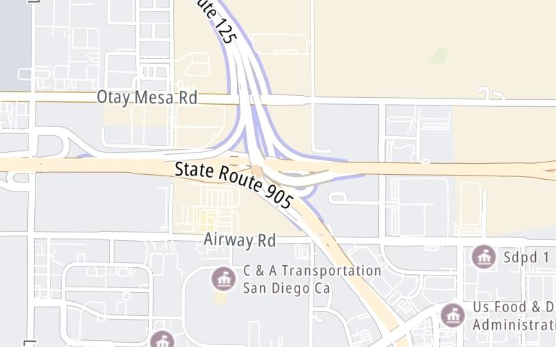
This junction is located in Otay Mesa. San Diego is nearby. NOTE: NB On Only.
This location is in the San Diego area.
This location's approximate GPS Coordinates are 32.56371 x -116.94717.
Which directions can I travel from here?
From this junction, traffic can only enter going northbound.
On to Otay Mesa Road / to CA 905, about 0.1 miles away ►
Which direction are tolls charged here?
Tolls are not charged or collected at this junction.
Above: Map image © TomTom Intl BVThe interactive map and lists on this page include key traveler services within two miles of this destination point.
You will find common services, including gas stations, truck stops, EV charging facilities, fast-food or family restaurants, and hotels. These are displayed on the interactive map as markers, which you can select for more information.
Current driving conditions and weather, along with a more complete list of key services, may be found below the map.

Cloudy
59°F / 15°C
Feels Like:
55°F / 12.8°C
Visibility
1 Mi / 1.6 Km
3-Hour Precip:
0 In / 0.0 Cm
West Southwest
Winds (WSW)
8.1 MPH / 13 KPH
Gusts:
8.3 MPH / 13.3 KPH
▸ Get the full forecast for This Location | The San Diego area
Conditions and forecasts provided in partnership with AccuWeather.

Weather provided in partnership with AccuWeather.
There is no currently-available traffic camera feed for this location.
There are no currently-available photos for this location.
The map above shows all services within about a two (2) mile radius.

Destination Travel

Closest Gas Stations
PILOT TRAVEL CENTER #343
1497 Piper Ranch Road • 0.48 miles
Store/Fuel Brand: Pilot Travel Center
SHELL SPEEDWAY
2435 Otay Center Drive • 0.69 miles
Store/Fuel Brand: Speedway
US GAS
2310 Roll Drive • 0.75 miles
Store/Fuel Brand:
ARCO
2510 Otay Center Drive • 0.77 miles
Store/Fuel Brand: Arco
Closest EV Chargers
CHARGEPOINT
8490 Avenida de la Fuente • 0.89 miles
CONNECTOR: IEC62196Type1CCS
POWER: 62 KW @ 1000 V
CURRENT: 62 Amp DC
TRUCK NET LLC
8490 Avenida de la Fuente • 0.93 miles
CONNECTOR: Chademo
POWER: 62 KW @ 1000 V
CURRENT: 62 Amp DC
SOUTHWESTERN COLLEGE HIGHER EDUCATION CENTER
8100 Gigantic Street • 1.17 miles
CONNECTOR: Chademo
POWER: 62 KW @ 1000 V
CURRENT: 62 Amp DC
CHARGEPOINT
8100 Gigantic Street • 1.22 miles
CONNECTOR: IEC62196Type1CCS
POWER: 62 KW @ 1000 V
CURRENT: 62 Amp DC

Closest Fast Food
Fast food refers ONLY to quick-service and take-out diners. All restaurant types are shown on the map above.
CINNABON
1497 Piper Ranch Road • 0.46 miles
WENDY'S
1497 Piper Ranch Road • 0.46 miles
JACK IN THE BOX
2525 Otay Center Drive • 0.75 miles
TERIYAKI MADNESS
2535 Otay Center Drive • 0.76 miles
MCDONALD'S
2320 Roll Drive • 0.76 miles
JAYS PRE-ROLLS
2335 Roll Drive • 0.81 miles
CARL'S JUNIOR
2365 Roll Drive • 0.83 miles
MARISCOS GONZALEZ
9030 Airway Road • 1,235 feet
Journey to key destinations around and adjacent to California!
Communities in this metro area include Los Angeles, Long Beach, Irvine, San Juan Capistrano, and Santa Ana.
Individual toll maps for this region are listed below.
Communities in this metro area include San Francisco, San Jose, Sausalito, and Menlo Park.
Individual toll maps for this region are listed below.
Communities in this metro area include San Diego, Chula Vista, and Tijuana, Mexico.
Individual toll maps for this region are listed below.
 CA 73 ▹
 CA 133 ▹
 CA 241 ▹
 CA 261 ▹
 Antioch Bridge ▹
 Benicia Martinez Bridge ▹
 Carquinez Bridge ▹
 Dumbarton Bridge ▹
 Golden Gate Bridge ▹
 Richmond San Rafael Bridge ▹
 San Mateo Hayward Bridge ▹
 South Bay Expressway ▹


