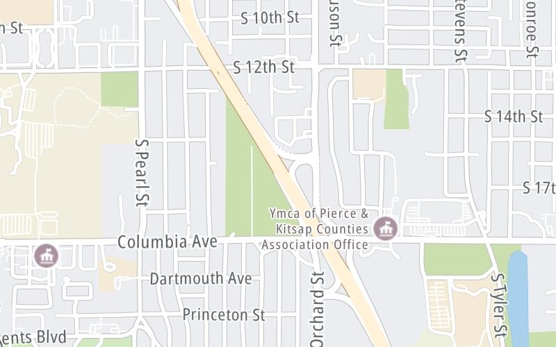
Map & services within two (2) miles
Interactive map shows available cameras, plus nearby fuel, food and lodging


See below for more about this area
Interactive map shows available cameras, plus nearby fuel, food and lodging
See below for more about this area
This is Exit 2A of the Tacoma Narrows Bridge.
This junction is located in Tacoma.
This location is in the Seattle - Tacoma area.
This location's approximate GPS Coordinates are 47.24565 x -122.50736.
Which directions can I travel from here?
From this junction, traffic can enter traveling both westbound and eastbound. Traffic can also exit traveling both westbound and eastbound.
On to Orchard Street / S 19th Street East, about 0.3 miles away ►
◄ Back to Pearl Street / 6th Avenue, about 0.8 miles away.
Which direction are tolls charged here?
Tolls are not charged or collected at this junction.
Above: Map image © TomTom Intl BVThe interactive map and lists on this page include key traveler services within two miles of this destination point.
You will find common services, including gas stations, truck stops, EV charging facilities, fast-food or family restaurants, and hotels. These are displayed on the interactive map as markers, which you can select for more information.
Current driving conditions and weather, along with a more complete list of key services, may be found below the map.

Cloudy
42°F / 5.5°C
Feels Like:
46°F / 7.8°C
Visibility
8 Mi / 12.9 Km
3-Hour Precip:
0 In / 0.0 Cm
South Southeast
Winds (SSE)
1.2 MPH / 1.9 KPH
Gusts:
2.9 MPH / 4.7 KPH
▸ Get the full forecast for This Location | The Seattle - Tacoma area
Conditions and forecasts provided in partnership with AccuWeather.

Weather provided in partnership with AccuWeather.

WA-16 @ 19TH ST
Camera Direction: WEST. Source: WSDOT - Tacoma 98405
Cameras Closest To S 19th Street West
0.26 Mi
0.96 Mi
1.41 Mi
1.77 Mi
2.43 Mi
There are no currently-available photos for this location.
The map above shows all services within about a two (2) mile radius.

Destination Travel

Closest Gas Stations
FRED MEYER FUEL CENTER
4505 South 19th Street • 0.49 miles
Store/Fuel Brand:
CHEVRON
4401 South 19th Street • 0.60 miles
Store/Fuel Brand: Chevron
7-ELEVEN
5110 6th Avenue • 0.65 miles
Store/Fuel Brand: 7-Eleven
ROYAL FAIR
5015 Center Street • 0.76 miles
Store/Fuel Brand: Mobil
Closest EV Chargers
CHARGEPOINT
6501 South 10th Street • 0.91 miles
CONNECTOR: IEC62196Type1
POWER: 6 KW @ 240 V
CURRENT: 27 Amp AC1
MCLENDON HARDWARE TACOMA
1015 North Pearl Street • 0.99 miles
CONNECTOR: IEC62196Type1
POWER: 8 KW @ 270 V
CURRENT: 32 Amp AC1
ALTA UNIVERSITY PLACE
2208 Mildred Street West • 1.06 miles
CONNECTOR: IEC62196Type1
POWER: 7 KW @ 240 V
CURRENT: 30 Amp AC1
CHARGEPOINT
1801 South Union Avenue • 1.17 miles
CONNECTOR: IEC62196Type1CCS
POWER: 62 KW @ 1000 V
CURRENT: 125 Amp DC

Closest Fast Food
Fast food refers ONLY to quick-service and take-out diners. All restaurant types are shown on the map above.
ESPRESS-O-YOURSELF
1009 Regents Boulevard • 0.61 miles
SONIC
5114 6th Avenue • 0.64 miles
MCDONALD'S
4814 Center Street • 0.84 miles
FLIPPING OUT BURGERS & FRIES
4008 South 12th Street • 0.84 miles
CHICK-FIL-A
6602 19Th Street West • 0.85 miles
BOBA SMOOTHIES & DONUT
4916 Center Street • 0.86 miles
JACK IN THE BOX
4702 Center Street • 0.86 miles
CRISP GREENS
4312 6th Avenue • 0.87 miles
Journey to key destinations around and adjacent to Washington!
Communities in this metro area include Seattle, Tacoma, Bellevue, Redmond, Kirkland, Artondale, and University Place.
Individual toll maps for this region are listed below.
 Tacoma Narrows Bridge ▹
 SR 99 Tunnel ▹
 SR 520 Bridge ▹


