Map & services within two (2) miles
Interactive map shows available cameras, plus nearby fuel, food and lodging


See below for more about this area
Interactive map shows available cameras, plus nearby fuel, food and lodging
See below for more about this area
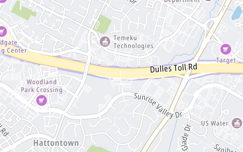
This junction is located in Reston. Herndon is nearby. NOTE: Monroe Park and Ride.
This location's approximate GPS Coordinates are 38.95242 x -77.38375.
Which directions can I travel from here?
From this junction, traffic can enter traveling both westbound and eastbound. Traffic can also exit traveling both westbound and eastbound.
On to SR 7100/Fairfax County Parkway, about 0.5 miles away ►
◄ Back to SR 657/Centreville Road, about 1.2 miles away.
Which direction are tolls charged here?
The interactive map and lists on this page include key traveler services within two miles of this destination point.
You will find common services, including gas stations, truck stops, EV charging facilities, fast-food or family restaurants, and hotels. These are displayed on the interactive map as markers, which you can select for more information.
Current driving conditions and weather, along with a more complete list of key services, may be found below the map.

Sunny
55°F / 13°C
Feels Like:
62°F / 16.7°C
Visibility
10 Mi / 16.1 Km
3-Hour Precip:
0 In / 0.0 Cm
North Northwest
Winds (NNW)
4.5 MPH / 7.2 KPH
Gusts:
9.8 MPH / 15.7 KPH
▸ Get the full forecast for This Location
Conditions and forecasts provided in partnership with AccuWeather.

Weather provided in partnership with AccuWeather.
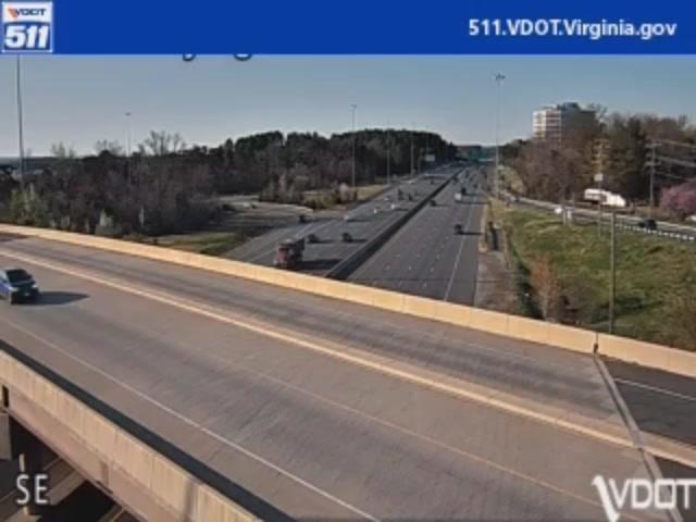
VA-28 / MM 38.1 / NB
Camera Direction: NORTH. Source: VDOT - undetermined 20171
Cameras Closest To Herndon
2.47 Mi
3.36 Mi
There are no currently-available photos for this location.
The map above shows all services within about a two (2) mile radius.

Destination Travel

Closest Gas Stations
SUNOCO
12191 Sunset Hills Road • 0.86 miles
Store/Fuel Brand: Sunoco
HERNDON AUTO CARE & TIRE CENTER
1131 Elden Street • 1.10 miles
Store/Fuel Brand:
SHELL
1121 Elden Street • 1.11 miles
Store/Fuel Brand: Shell
SUNOCO
2150 Centreville Road • 1.12 miles
Store/Fuel Brand: Sunoco
Closest EV Chargers
12851 WORLDGATE DRIVE
12851 Worldgate Drive • 0.41 miles
CONNECTOR: IEC62196Type1
POWER: 6 KW @ 208 V
CURRENT: 30 Amp AC1
12901 WORLDGATE DRIVE
12901 Worldgate Drive • 0.43 miles
CONNECTOR: IEC62196Type1
POWER: 6 KW @ 208 V
CURRENT: 30 Amp AC1
ELECTRIFY AMERICA CENTER OF EXCELLENCE
300 Victory Drive • 0.44 miles
CONNECTOR: IEC62196Type1
POWER: 6 KW @ 208 V
CURRENT: 30 Amp AC1
12825 WORLDGATE DRIVE
12825 Worldgate Drive • 0.66 miles
CONNECTOR: IEC62196Type1
POWER: 6 KW @ 208 V
CURRENT: 30 Amp AC1

Closest Fast Food
Fast food refers ONLY to quick-service and take-out diners. All restaurant types are shown on the map above.
WEIRD BROTHERS COFFEE
321 Sunset Park Drive • 0.60 miles
MOE'S SOUTHWEST GRILL
12950 Highland Crossing Drive • 0.60 miles
WOOBOI HOT CHICKEN
139 Spring Street • 0.68 miles
CHICK-FIL-A
12160 Sunset Hills Road • 0.94 miles
CHIPOTLE
12152 Sunset Hills Road • 0.96 miles
POTBELLY
12150 Sunset Hills Road • 0.96 miles
QDOBA
13031 Worldgate Drive • 0.98 miles
PANERA BREAD
13041 Worldgate Drive • 1.00 miles
Journey to key destinations around and adjacent to Virginia!
Communities in this metro area include Richmond, Meadowbrook, Manchester, and Brandermill.
Individual toll maps for this region are listed below.
Communities in this metro area include Norfolk, Chesapeake, Virginia Beach, Newport News, Portsmouth, Suffolk, and Moyock, North Carolina.
Individual toll maps for this region are listed below.
Communities in this metro area include Washington, Dc, Fairfax County, Virginia, Loundoun County, Virginia, Montgomery County, Maryland, and Prince George's County, Maryland.
Individual toll maps for this region are listed below.
Communities in this metro area include Pittsburgh, Cranberry Township, Beaver Valley, New Castle, Washington, Uniontown, Cheat Lake, West Virginia, Boardman, Ohio, and Youngstown, Ohio.
Individual toll maps for this region are listed below.
Communities in this metro area include Charleston, Malden, South Ruffner, and Snow Hill.
Individual toll maps for this region are listed below.

Communities in this metro area include Beckley, Beaver, Mac Arthur, Daniels, and Shady Spring.
Individual toll maps for this region are listed below.

 Boulevard Bridge ▹
 Downtown Expressway ▹
 Pocahontas Parkway ▹
 Powhite Parkway ▹
 Chesapeake Bay Bridge Tunnel ▹
 Chesapeake Expressway ▹
 Downtown Tunnel ▹
 South Norfolk Jordan Bridge ▹
 Midtown Tunnel ▹
 Dominion Boulevard Veterans Bridge ▹
 Wm Preston Lane Jr Memorial Bridge ▹
 Intercounty Connector MD 200 ▹
 Dulles Greenway ▹
 PA Turnpike 66 ▹
 Beaver Valley Expressway ▹
 Mon Fayette Expressway ▹
 Pennsylvania Turnpike ▹
 Ohio Turnpike ▹
 PA Turnpike 576 ▹
 West Virginia Turnpike ▹


