Map & services within two (2) miles
Interactive map shows available cameras, plus nearby fuel, food and lodging


See below for more about this area
Interactive map shows available cameras, plus nearby fuel, food and lodging
See below for more about this area
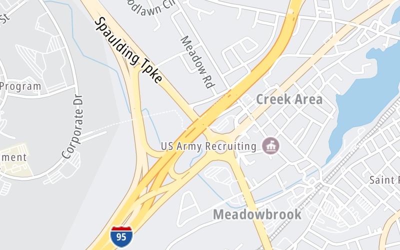
This junction is located in Portsmouth. NOTE: SB Off/NB On.
This location is in the Portsmouth - Dover area.
This location's approximate GPS Coordinates are 43.07426 x -70.78271.
Which directions can I travel from here?
From this junction, traffic can only enter going northbound. Traffic can only exit going southbound.
On to Brady Drive / to Woodbury Ave, about 1.1 miles away ►
◄ Back to I–95 / Blue Star Turnpike, about 0.0 miles away.
▹ The Spaulding Turnpike and the Blue Star Turnpike connect here.
Which direction are tolls charged here?
Tolls are not charged or collected at this junction.
Above: Map image © TomTom Intl BVThe interactive map and lists on this page include key traveler services within two miles of this destination point.
You will find common services, including gas stations, truck stops, EV charging facilities, fast-food or family restaurants, and hotels. These are displayed on the interactive map as markers, which you can select for more information.
Current driving conditions and weather, along with a more complete list of key services, may be found below the map.

Cloudy
45°F / 7°C
Feels Like:
47°F / 8.5°C
Visibility
6 Mi / 9.7 Km
3-Hour Precip:
0 In / 0.0 Cm
East Northeast
Winds (ENE)
1.1 MPH / 1.8 KPH
Gusts:
3.2 MPH / 5.2 KPH
▸ Get the full forecast for This Location | The Portsmouth - Dover area
Conditions and forecasts provided in partnership with AccuWeather.

Weather provided in partnership with AccuWeather.
There is no currently-available traffic camera feed for this location.
There are no currently-available photos for this location.
The map above shows all services within about a two (2) mile radius.

Destination Travel

Closest Gas Stations
BYPASS GAS AND MORE
822 US Highway 1 Bypass • 0.44 miles
Store/Fuel Brand:
U-HAUL
400 US Highway 1 Bypass • 0.59 miles
Store/Fuel Brand:
AMPET
921 Islington Street • 0.64 miles
Store/Fuel Brand:
ISLINGTON SUNOCO
565 Islington Street • 0.65 miles
Store/Fuel Brand: Sunoco
Closest EV Chargers
CHARGEPOINT
94 Coakley Road • 0.41 miles
CONNECTOR: IEC62196Type1
POWER: 6 KW @ 240 V
CURRENT: 27 Amp AC1
WEST END YARDS
35 Hodgdon Way • 0.45 miles
CONNECTOR: IEC62196Type1
POWER: 6 KW @ 208 V
CURRENT: 30 Amp AC1
ABM - HOLLOWAY BUICK GMC CADILLAC
500 Rte 1 Bypass South • 0.54 miles
CONNECTOR: IEC62196Type1
POWER: 16 KW @ 214 V
CURRENT: 80 Amp AC1
THE FRANK JONES 1884 HOUSE
110 Brewery Lane • 0.71 miles
CONNECTOR: IEC62196Type1
POWER: 7 KW @ 240 V
CURRENT: 30 Amp AC1

Closest Fast Food
Fast food refers ONLY to quick-service and take-out diners. All restaurant types are shown on the map above.
WENDY'S
1465 Woodbury Avenue • 1.06 miles
MCDONALD'S
49 Gosling Road • 1.51 miles
CUMBERLAND FARMS
97 Gosling Road • 1.53 miles
BADGERS ISLAND PIZZA
3 Island Avenue • 1.69 miles
Journey to key destinations around and adjacent to New Hampshire!
Communities in this metro area include Hooksett, Concord, Manchester, and West Concord.
Individual toll maps for this region are listed below.

Communities in this metro area include Portsmouth, Dover, Durham, Rochester, Kittery, Maine, and York, Maine.
Individual toll maps for this region are listed below.

 Everett Turnpike ▹
 Blue Star Turnpike ▹
 Spaulding Turnpike ▹
 Maine Turnpike ▹


