Map & services within two (2) miles
Interactive map shows available cameras, plus nearby fuel, food and lodging

See below for more about this area
Interactive map shows available cameras, plus nearby fuel, food and lodging
See below for more about this area
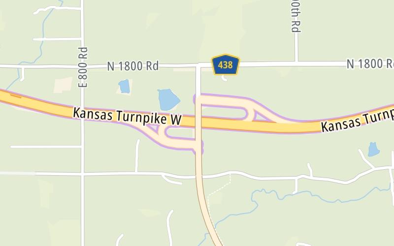
This is Exit 197 of the Kansas Turnpike.
This junction is located in Lawrence. Kanwaka is nearby.
This location is in the Kansas City - Topeka area.
This location's approximate GPS Coordinates are 38.99653 x -95.34394.
Which directions can I travel from here?
From this junction, traffic can enter traveling both southbound and northbound. Traffic can also exit traveling both southbound and northbound.
On to Lawrence US59-US40/Lecompton Zone Gantry, about 3.5 miles away ►
◄ Back to Lecompton K-10/Topeka I-70 Zone EB Gantry, about 6.0 miles away.
Which direction are tolls charged here?
The interactive map and lists on this page include key traveler services within two miles of this destination point.
You will find common services, including gas stations, truck stops, EV charging facilities, fast-food or family restaurants, and hotels. These are displayed on the interactive map as markers, which you can select for more information.
Current driving conditions and weather, along with a more complete list of key services, may be found below the map.

Cloudy
47°F / 8.5°C
Feels Like:
43°F / 6°C
Visibility
10 Mi / 16.1 Km
3-Hour Precip:
0 In / 0.0 Cm
East Southeast
Winds (ESE)
7.8 MPH / 12.6 KPH
Gusts:
15.8 MPH / 25.5 KPH
▸ Get the full forecast for This Location | The Kansas City - Topeka area
Conditions and forecasts provided in partnership with AccuWeather.

Weather provided in partnership with AccuWeather.
There is no currently-available traffic camera feed for this location.
There are no currently-available photos for this location.
The map above shows all services within about a two (2) mile radius.

Destination Travel

Closest Gas Stations
No gas or other fuel stations nearby.
Closest EV Chargers
CHARGEPOINT
100 Rock Chalk Lane • 1.38 miles
CONNECTOR: IEC62196Type1
POWER: 6 KW @ 240 V
CURRENT: 27 Amp AC1
WEST LAWRENCE HOTEL
6101 Rock Chalk Drive • 1.54 miles
CONNECTOR: IEC62196Type1
POWER: 7 KW @ 240 V
CURRENT: 30 Amp AC1

Closest Fast Food
Fast food refers ONLY to quick-service and take-out diners. All restaurant types are shown on the map above.
No fast-food dining nearby.
Journey to key destinations around and adjacent to Kansas!
Communities in this metro area include Kansas City, Kansas City, Missouri, Topeka, Lawrence, Overland Park, Edwardsville, and Bonner Springs.
Individual toll maps for this region are listed below.
Communities in this metro area include Wichita, Bel Aire, Andover, Valley Center, and Maize.
Individual toll maps for this region are listed below.

Communities in this metro area include Tulsa, Broken Arrow, Muskogee, Stillwater, Sapulpa, Vinita, Joplin, Missouri, Siloam Springs, Arkansas, and San Springs.
Individual toll maps for this region are listed below.
Communities in this metro area include Stillwater and Tulsa.
Individual toll maps for this region are listed below.

 Kansas Turnpike ▹
 Cimarron Turnpike ▹
 Creek Turnpike ▹
 Muskogee Turnpike ▹
 Turner Turnpike ▹
 Will Rogers Turnpike ▹
 Gilcrease Expressway West ▹


