Map & services within two (2) miles
Interactive map shows available cameras, plus nearby fuel, food and lodging


See below for more about this area
Interactive map shows available cameras, plus nearby fuel, food and lodging
See below for more about this area
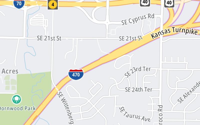
This is Exit 182 of the Kansas Turnpike.
This junction is located in Tecumseh. Topeka is nearby. NOTE: SB On/NB Off.
This location is in the Kansas City - Topeka area.
This location's approximate GPS Coordinates are 39.02644 x -95.62445.
Which directions can I travel from here?
From this junction, traffic can only enter going southbound. Traffic can only exit going northbound.
On to ORT East Topeka Zone Gantry, about 1.7 miles away ►
◄ Back to Topeka K-4/I-470 Zone Gantry, about 2.4 miles away.
Which direction are tolls charged here?
The interactive map and lists on this page include key traveler services within two miles of this destination point.
You will find common services, including gas stations, truck stops, EV charging facilities, fast-food or family restaurants, and hotels. These are displayed on the interactive map as markers, which you can select for more information.
Current driving conditions and weather, along with a more complete list of key services, may be found below the map.

Cloudy
52°F / 11.1°C
Feels Like:
45°F / 7.4°C
Visibility
10 Mi / 16.1 Km
3-Hour Precip:
0 In / 0.0 Cm
Southeast
Winds (SE)
18.4 MPH / 29.6 KPH
Gusts:
25.3 MPH / 40.8 KPH
▸ Get the full forecast for This Location | The Kansas City - Topeka area
Conditions and forecasts provided in partnership with AccuWeather.

Weather provided in partnership with AccuWeather.
There is no currently-available traffic camera feed for this location.
There are no currently-available photos for this location.
The map above shows all services within about a two (2) mile radius.

Destination Travel

Closest Gas Stations
THE DOCK
2838 Southeast 29th Street • 0.85 miles
Store/Fuel Brand: Phillips 66
BP STATION
Southeast 29th Street • 0.87 miles
Store/Fuel Brand: BP
KRIS 2
2841 Southeast Croco Road • 0.90 miles
Store/Fuel Brand:
LAKEVIEW 66
3000 Southeast Croco Road • 1.07 miles
Store/Fuel Brand: Phillips 66
Closest EV Chargers
No EV charging stations nearby.

Closest Fast Food
Fast food refers ONLY to quick-service and take-out diners. All restaurant types are shown on the map above.
SONIC
3520 Southeast 29th Street • 0.88 miles
SEñOR BUR-RITO'S TACO SHOP
2841 Southeast Croco Road • 0.91 miles
HUNT BROTHERS PIZZA
3000 Southeast Croco Road • 1.08 miles
KRISPY KRUNCHY CHICKEN
3100 Southeast 6th Avenue • 1.41 miles
CHIPOTLE
2001 Southeast 28th Street • 1.59 miles
MCDONALD'S
2880 Southeast California Avenue • 1.61 miles
BURGER KING
2817 Southeast California Avenue • 1.63 miles
DOMINO'S
2835 Southeast California Avenue • 1.67 miles
Journey to key destinations around and adjacent to Kansas!
Communities in this metro area include Kansas City, Kansas City, Missouri, Topeka, Lawrence, Overland Park, Edwardsville, and Bonner Springs.
Individual toll maps for this region are listed below.
Communities in this metro area include Wichita, Bel Aire, Andover, Valley Center, and Maize.
Individual toll maps for this region are listed below.

Communities in this metro area include Tulsa, Broken Arrow, Muskogee, Stillwater, Sapulpa, Vinita, Joplin, Missouri, Siloam Springs, Arkansas, and San Springs.
Individual toll maps for this region are listed below.
Communities in this metro area include Stillwater and Tulsa.
Individual toll maps for this region are listed below.

 Kansas Turnpike ▹
 Cimarron Turnpike ▹
 Creek Turnpike ▹
 Muskogee Turnpike ▹
 Turner Turnpike ▹
 Will Rogers Turnpike ▹
 Gilcrease Expressway West ▹


