Map & services within two (2) miles
Interactive map shows available cameras, plus nearby fuel, food and lodging


See below for more about this area
Interactive map shows available cameras, plus nearby fuel, food and lodging
See below for more about this area
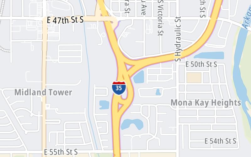
This is Exit 42 of the Kansas Turnpike.
This junction is located in Wichita. Salina is nearby.
This location is in the Wichita - Mcconnel AFB area.
This location's approximate GPS Coordinates are 37.60147 x -97.32293.
Which directions can I travel from here?
From this junction, traffic can enter traveling both southbound and northbound. Traffic can also exit traveling both southbound and northbound.
On to K15, about 2.4 miles away ►
◄ Back to Wichita K-15/I-135/235 Zone Gantry, about 0.4 miles away.
Which direction are tolls charged here?
The interactive map and lists on this page include key traveler services within two miles of this destination point.
You will find common services, including gas stations, truck stops, EV charging facilities, fast-food or family restaurants, and hotels. These are displayed on the interactive map as markers, which you can select for more information.
Current driving conditions and weather, along with a more complete list of key services, may be found below the map.

Cloudy
45°F / 7°C
Feels Like:
41°F / 5°C
Visibility
10 Mi / 16.1 Km
3-Hour Precip:
0 In / 0.0 Cm
Southeast
Winds (SE)
6.6 MPH / 10.7 KPH
Gusts:
13 MPH / 20.9 KPH
▸ Get the full forecast for This Location | The Wichita - Mcconnel AFB area
Conditions and forecasts provided in partnership with AccuWeather.

Weather provided in partnership with AccuWeather.
There is no currently-available traffic camera feed for this location.
There are no currently-available photos for this location.
The map above shows all services within about a two (2) mile radius.

Destination Travel

Closest Gas Stations
JUMP START
1131 East 47th Street South • 0.42 miles
Store/Fuel Brand:
QUIKTRIP
1623 East 47th Street South • 0.55 miles
Store/Fuel Brand: QuikTrip
DILLONS
4747 South Broadway Avenue • 0.80 miles
Store/Fuel Brand: Dillons Fuel Center
QUIKTRIP
5611 South Broadway Avenue • 0.86 miles
Store/Fuel Brand: QuikTrip
Closest EV Chargers
WICHITA, KS SUPERCHARGER
4760 South Broadway Avenue • 0.75 miles
CONNECTOR: Tesla
POWER: 150 KW @ 400 V
CURRENT: 375 Amp DC

Closest Fast Food
Fast food refers ONLY to quick-service and take-out diners. All restaurant types are shown on the map above.
HUNT BROTHERS PIZZA
1131 East 47th Street South • 0.42 miles
ARBY'S
4815 South Washington Avenue • 0.46 miles
KFC
611 East 47th Street South • 0.56 miles
BURGER KING
501 East 47th Street South • 0.59 miles
HOG-WILD PIT BBQ
630 East 47th Street South • 0.62 miles
LITTLE CAESARS
5000 South Broadway Avenue • 0.62 miles
BRAUM'S
550 East 47th Street South • 0.65 miles
TACO BELL
422 East 47th Street South • 0.67 miles
Journey to key destinations around and adjacent to Kansas!
Communities in this metro area include Kansas City, Kansas City, Missouri, Topeka, Lawrence, Overland Park, Edwardsville, and Bonner Springs.
Individual toll maps for this region are listed below.
Communities in this metro area include Wichita, Bel Aire, Andover, Valley Center, and Maize.
Individual toll maps for this region are listed below.

Communities in this metro area include Tulsa, Broken Arrow, Muskogee, Stillwater, Sapulpa, Vinita, Joplin, Missouri, Siloam Springs, Arkansas, and San Springs.
Individual toll maps for this region are listed below.
Communities in this metro area include Stillwater and Tulsa.
Individual toll maps for this region are listed below.

 Kansas Turnpike ▹
 Cimarron Turnpike ▹
 Creek Turnpike ▹
 Muskogee Turnpike ▹
 Turner Turnpike ▹
 Will Rogers Turnpike ▹
 Gilcrease Expressway West ▹


